Marine Stewardship Areas
Whidbey and Camano islands -- Island County -- sit at the gateway to Washington's extraordinary Puget Sound. Nearly every fish, marine mammal, ship and submarine that enters and leaves this vast estuary passes our shores.
More than 1,000 rivers and streams feed fresh water into Puget Sound. Where the fresh and salt water meet, our tides mix them in an ever-changing nutrient soup. Among all the estuaries in the United States, Puget Sound is second only to Chesapeake Bay in size. Puget Sound's salmon, steelhead, orcas, birds and other wildlife are priceless to our lifestyle. Their health and that of our marine waters are tied closely to our own. They are also crucial to our economy.
At the request of the Island County Marine Resources Committee, Island County Commissioners created the Admiralty Inlet and Saratoga Passage Marine Stewardship Areas in 2003. In 2013 and 2014, Island and Snohomish County Commissioners adopted resolutions in their respective counties creating the Port Susan Marine Stewardship Area. This resulted from the collaboration of several regional partners. Marine Stewardship Areas focus greater awareness and education on the unique marine assets of our Island County waters. Their purpose is education and voluntary change -- not regulation.
Please explore this website to learn more about stewardship, these three large stewardship areas, and how you can help. If you own waterfront property or live in a community with shared access rights to the shoreline, please consider becoming a Shore Steward. If you'd like to volunteer to conduct research or perform other service to benefit the marine environment, please consider applying for the training course to become a Sound Water Steward.

Admiralty Inlet MSA
Whidbey Island's west-side beaches face some of the stiffest winds and highest energy wave action in Puget Sound. Just off West Beach on northern Whidbey Island lies Puget Sound's largest kelp forest. Nearby Smith and Minor islands, part of the San Juan Islands National Wildlife Refuge, are a major sanctuary for marine birds and mammals. The state Department of Natural Resources has designated this area the Smith and Minor Islands Aquatic Reserve.
In the 19th century tall ships rode the winds into Admiralty Inlet and Puget Sound. Today, ferry boats from Port Townsend battle tricky long-shore currents to harbor at Keystone.
Salmon follow the oxygen-rich Whidbey shore as they migrate to sea and back. Sport-fishers intercept them from beach and boats. Orcas, gray whales, sea lions, birds and geoducks use the beaches, marine waters and tidelands of Admiralty Inlet. Cruise ships, container vessels, oil barges and nuclear submarines pass above.

Small estuaries, lagoons and creek mouths offer young salmon a place to rest and avoid predators. Eelgrass beds provide additional shelter and spawning habitat for the herring they eat. Glacial bluffs shed earth to the beaches below, replenishing egg-laying gravels for two other forage fish the salmon love — sand lance and surf smelt.
In addition to natural riches this beautiful shore is rich in history as well. British explorer, Captain George Vancouver of the HMS Discovery, named the bluff at Admiralty Head in 1792 in honor of the British Lords of the Admiralty. The US government built a lighthouse here in 1861 and later a coastal defense installation, Fort Casey, that is now a state park.
Admiralty Inlet Marine Stewardship Area spans the breadth, depth and length of Island County waters west of Whidbey Island from Deception Pass in the north to Possession Point in the south.

Saratoga Passage Marine Stewardship Area
Nestled between Camano and Whidbey islands, Saratoga Passage is the primary marine highway for recreational boaters traveling between Puget Sound's population centers to the south and the San Juan Islands to the north.
This sheltered passage is sometimes called "the salmon highway" for its many excellent forage fish spawning beaches and nearly continuous eelgrass beds, which provide food and refuge to migrating salmon. Three large fish-producing river systems open into Saratoga Passage and nearby Port Susan -- the Skagit, Stillaguamish and Snohomish. Small estuaries, lagoons and creek mouths dot the shore, giving young salmon a place to rest and adjust to saltwater after leaving their rivers. Glacial bluffs slough till to the beaches, replenishing spawning gravels for the sand lance and surf smelt on which they rely. Orcas, grey whales, sea lions and birds frequent these beaches and marine waters.
Much of the county's shoreline development has centered on this passage since early Salish times and continues today with all five of the county's cities and towns - Oak Harbor, Coupeville, Freeland, Langley and Clinton. This quiet inland sea was trafficked by canoes, tall ships, mosquito fleet steamers and sternwheelers before today's sail and powerboats.
Saratoga Passage Marine Stewardship Area spans all the inland waters of Island County from Deception Pass and Skagit Bay in the north to Port Susan Bay in the east and Possession Point in the south.

Port Susan Marine Stewardship Area
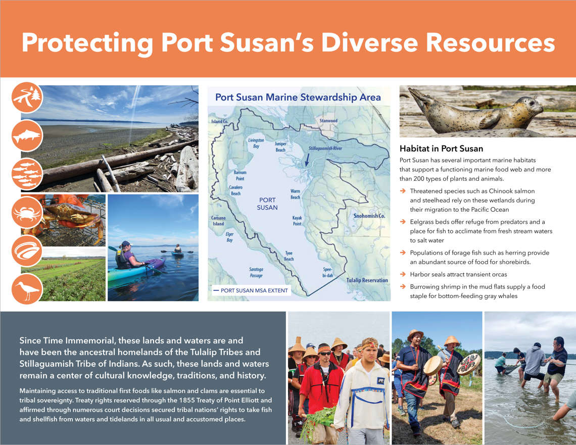
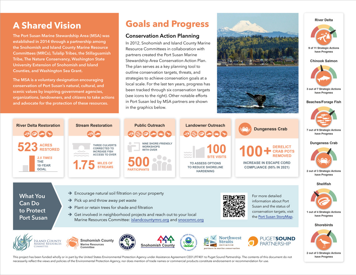
Port Susan Bay straddles Island and Snohomish counties from the Marysville area north to Stanwood and west to Camano Island. Since 2007 we have been partnering with Snohomish County MRC in a community process to develop a science-based marine stewardship area for this body of water. Additional partners include the Tulalip Tribes, Stillaguamish Tribe, The Nature Conservancy, Washington Sea Grant with the support of the Northwest Straits Commission, and the WSU Extension offices of Island and Snohomish counties.
On Dec. 6, 2011 the Island and Snohomish MRCs voted unanimously in a joint meeting to recommend adoption of the plan to elected leaders of Island and Snohomish counties. In 2012, the Port Susan MSA plan entered Phase II of the CAP planning process. During this final planning phase the MSA Team continued to work with partner organizations to develop a Conservation Workplan and Measures Plan. View a PDF of the complete plan.

Port Susan Bay is renowned for salmon, Pacific sturgeon, gray whales, clams, crabs, oysters and thousands of migratory waterfowl. The bay's fish and shellfish are harvested both commercially and recreationally. Surf smelt lay their eggs on the bay's sandy beaches and ghost shrimp burrow in the muddy shallows. Salmon and birds feed on the smelt. Gray whales enter the bay every spring on their migration from Mexico to Alaska. They scoop mouthfuls of bottom and sift it for ghost shrimp. Sturgeon visit the bay from the Columbia and Fraser rivers to forage for worms and shellfish.
The bay and its various estuaries also function as a salmon nursery. Juvenile Chinook, Coho and Chum salmon swim here and are carried by the currents from their birthplaces in the Skagit, Stillaguamish and Snohomish rivers. They probe the shoreline for pocket estuaries and creeks. Such places help them adjust their metabolism from river to saltwater environment, feed on insects that drop from overhanging vegetation, and hide from predators. Steelhead, cutthroat trout and other fish also use the estuarine habitat of this shore and nearby Livingston Bay.
Only recently have we really understood how valuable estuaries and salt marshes are to the entire marine food chain. Decades of logging, farming and home-building altered much of our shoreline. Today, only a few precious pockets of marsh and coastal wetland habitat remain. The Audubon Society has designated Port Susan Bay an Important Bird Area. State, tribes and private organizations are working to protect many sections of this bay’s shoreline. With public understanding and support of their efforts, future generations will continue to enjoy the beauty and diversity of birds, fish, marine mammals and other wildlife that make Port Susan Bay such a magical place to live and visit.
Resources
- Targeted Outreach to Reduce Impacts from Shore Armor in the Port Susan Marine Stewardship Area Program Assessment Summary Report
- Additional background courtesy of Snohomish County MRC website. To read more about the Port Susan Bay MSA process, please visit the website of our colleagues at Snohomish County MRC.
About Stewardship
Stewardship is an ethic people embrace willingly and voluntarily -- not a set of rules imposed by law. We become stewards by choice because we value clean water, safe food and a healthy environment, and want to pass these blessings to the next generation. We take responsibility to learn about, respect and care for that which is in our trust. As we learn we gain new insights about the land we own and beaches we use. We begin to see in new ways and enjoy them more. We make wiser decisions about how to manage and treat them.
More Information
- Resolution Creating Admiralty Inlet and Saratoga Passage Stewardship Areas
- Port Susan Marine Stewardship Area -- 5 minute video from Snohomish County Marine Resources Committee
- Estuary Soup -- 1 minute video from KCBY Coos Bay, OR
- Estuaries: Where the River Meets the Sea -- 2 minute video from NOAA
- Estuaries and Salt Marshes in Puget Sound -- 10 minute video from Journal of Accessible Science
- What's An Estuary? -- 5 minute video from EPA
- Blue Carbon – A Story from the Snohomish Estuary -- 5 minute video from EarthCorps
- Climate Change Threats to Estuaries in the Pacific Northwest -- one-hour presentation from US Fish and Wildlife
- How Stormwater Is Threatening the Puget Sound’s Fragile Ecosystem -- 5 minute video from The Nation